Study area & data collection
Study area
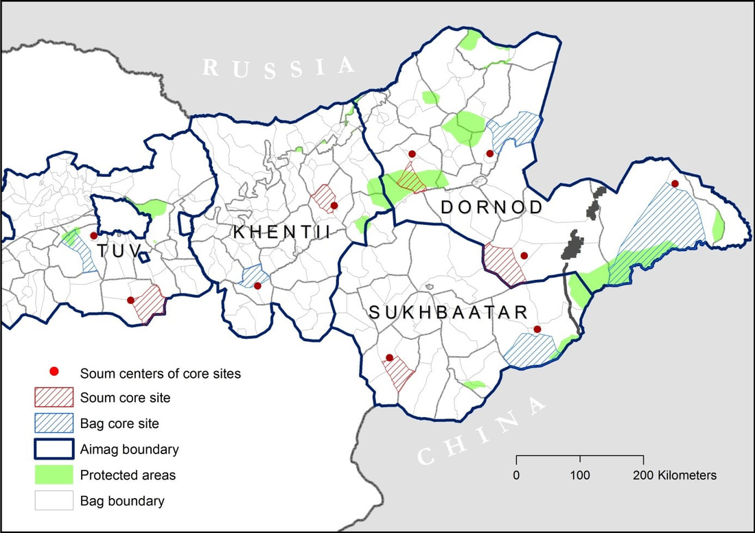
The study area of the MORE STEP project covers an area of 369,638 km2 within the provinces (called Aimag in Mongolian) Tuv, Khentii, Sukhbaatar, and Dornod in Mongolia. The study area represents the Mongolian Steppe Ecosystem, which is the largest mostly-intact steppe ecosystem worldwide and is characterized by a close coupling of societal and ecological processes. However, the Mongolian steppe is currently undergoing social-ecological transformations leading to the reduced mobility of nomadic wildlife and pastoralists. In particular many nomadic pastoralists increasingly adopt sedentary and more urban lifestyles in the western part of the study area, but the relative intact steppe occurs further east. This disturbance gradient in our study area, ranging from the more densely populated and overgrazed areas in the west to the less populated and pristine areas further in the east, provides a unique opportunity for scientists to investigate the effects of societal changes including urbanization, changing nomadic lifestyles, economic development, and policy instruments on the Mongolian rangelands and the mobility of wildlife and pastoralists.
Social-ecological data collection
At the center of the MORE STEP project is a field sampling strategy that allows for social and ecological surveys in the same area to create a social-ecological database that records information on herder and wildlife mobility along the disturbance gradient. To create this social-ecological database across the vast study region, the project teams selected two sampling sites in each province, except in Dornod, where we selected four sampling sites due to its large size. We call these 10 sampling sites ‘core sites.’ Five out of the ten core sites locate near population centers, which we called Soum sites, where we expect a high degree of disturbance, including more degraded vegetation. The other five core sites are placed in areas with a lower density of people and livestock so we can also sample less degraded areas of the steppe. Most of these sites are within protected areas or areas near the border to Russia and China and we called them Bag sites. Soums are administrative units within Aimags, while Bags are smaller areas within Soums. Through this set-up we can look both at local disturbance gradients (within Bag and Soum sites) but also a larger disturbance gradient from west to east. Our first sites are near Ulaanbaatar, in the west, where there is a higher population density. The other sites are progressively further east where there are fewer people.
Our integrated sampling design allows the diverse research teams to collect data together, which is pooled into a common social-ecological database. In total 11 teams, including MORE STEP researchers, students, field assistants and drivers of the field vehicles, conducted fieldwork simultaneously from July to September in 2019. For each core site, social scientists conducted qualitative and quantitative social interviews to collect socio-economic and social-ecological data at different scales ranging from herder households to local and regional administrative levels. In addition, botanists together with remote sensing specialists collected data on vegetation, while wildlife ecologists collected dung samples form livestock and Mongolian gazelles to examine diet and forage quality. Wildlife ecologists also deployed GPS tracking devices on livestock and Mongolian gazelles to collect animal movement data.
Our integrated sampling design allows the diverse research teams to collect data together, which is pooled into a common social-ecological database. In total 11 teams, including MORE STEP researchers, students, field assistants and drivers of the field vehicles, conducted fieldwork simultaneously from July to September in 2019. For each core site, social scientists conducted qualitative and quantitative social interviews to collect socio-economic and social-ecological data at different scales ranging from herder households to local and regional administrative levels. In addition, botanists together with remote sensing specialists collected data on vegetation, while wildlife ecologists collected dung samples form livestock and Mongolian gazelles to examine diet and forage quality. Wildlife ecologists also deployed GPS tracking devices on livestock and Mongolian gazelles to collect animal movement data.
Find out more about our diverse field efforts by following the links below


